

Our time in Marlborough Sound has come to an end. How did we decide or determine how long to spend here? Well, we didn’t get tired of the breathtaking vistas, changing locations often and the friendly people. No! In fact all of it exceeded our expectations. The real determining factor for us was, “It has gotten too darn cold and it’s time to break out the parkas.”
We endured and have even tolerated the colder temperatures of New Zealand, but here it is just too cold for us and it’s time for us to start getting serious about our northbound migration. So, the question arose as to how we plan our travels with regards to weather. When do you pull anchor and leave? What about storms? Big seas? Strong winds? The Kraken? UFO’s? And the list goes on depending on who you are talking with or how many adult beverages you’ve consumed.
There is some voodoo, science or plan to the whole process. First of all, we are not trend setters and others have most definitely gone on before us. So, we learn from their experiences and warnings and use them as a base for our strategy. Secondly, I pour over weather reports a few weeks before a possible passage. I watch the ever changing world of squiggly lines and colors on the global GRIB files from sources like Windy TY, PredictWind, MetVuw and others. The swirling colors are so pretty especially after a few cold beers.
Occasionally I pull out my crystal ball and perform the following chant while standing on one leg. “Innie beanie, chillie weenie, the spirits are about to speak!” Wait for it…..all of a sudden I hear the distinct sound of a beer can pop top break the silence. A small cloud appeared in the crystal ball and then, drum roll please……these words appear….…”Flip a Coin.” Maybe it was actually my magic 8 ball. LOL Not very scientific if you ask me.
There is no one source or person to tell you when to depart. Your fate is in your own ability to decipher the color by numbers properly on your GRIB charts. By looking at the different weather sites available you carefully try to calculate your course, the effects of the possible weather and sea conditions and then you throw a dart at the departure board. LOL
You know weather forecasting has a long and distinguished track record with greats like Coachella Valley’s own long time meteorologist Carl Garczynski. Or, Dr. George Fishbeck, meteorologist of the Los Angeles area local news and weather guru. There are many more, but these two men are who I grew up with and whose weather predictions I learned to trust. This doesn’t mean I ever wanted the dubious job title of prognosticator of weather phenomenons. but here I am playing that roll to be sure we have the smoothest, safest, uneventful passage.
Okay, get on with it. After pouring over the weather sites for the last two weeks, I see a possible opening in the weather pattern for a departure from Marlborough Sound to Wellington. Jilly has already been online looking at all the possible tourist sites to visit while in Wellington. Good grief! Me, I’m still trying to nail down our departure so as not to get our butts kicked by Mother Nature.
You see, we have to navigate two formidable natural navigational hazards. The Tory Channel at the east end of Marlborough Sound and the infamous Cook Straight. Okay, so I really don’t need to have the added navigational pressure of ensuring our safe passage but, it is a reality. There is no commercial announcer saying, ”Calgon take me away”, happening here.
After reading cruising sites with dedicated information about navigating both Tory Channel and the Cook Straight, I used that information and made adjustments for the tides and weather. I flipped a coin, consulted the crystal ball one more time, as you do, and decided on a firm departure plan.
Courtesy of Wikipedia. Cook Strait (Māori: Te Moana-o-Raukawa) separates the North and South Islands of New Zealand. The strait connects the Tasman Sea on the northwest with the South Pacific Ocean on the southeast, and runs next to the capital city, Wellington. It is 22 kilometers (14 mi) wide at its narrowest point and is considered one of the most dangerous and unpredictable waters in the world. Regular ferry services run between Picton in the Marlborough Sounds and Wellington.
The strait is named after James Cook, the first European commander to sail through it, in 1770. In Māori it has the name Raukawa or Te Moana-o-Raukawa (“The Sea of Raukawa”). Raukawa may mean “bitter leaves”.

Add to the Mix, The Karori Rip
What the hell is this monster? Well I’ll tell you Shoutie. The Karori Rip occurs between Cape Terawhiti and Sinclair Head west of Wellington Harbor along the northern border of the Cook Straight. And, we will have to pass by it on our way to Wellington. This area is marked with a caution symbol on our charts and is known to have severe standing waves at certain times during the tidal and current flows from the two adjoining seas. It is reported that this phenomenon can occur up to 2.75 miles offshore. This adventure keeps getting better and better. Perhaps it’s a portal to Worlds End? Jilly is trying to keep the calm face and although she denies it, I can tell that inside she is very anxious about our planned travels.


We talked with Troy, our dock neighbor in Picton, who has been a commercial fisherman in the area for over 30 years. He provided some tips and greatly helped build our confidence for exiting Tory Channel. Local knowledge is a far greater tool than all the literature available. Just another very useful tool to employ if and when it’s available.
We completed getting a few provisions, said our goodbyes to the staff at the Picton Marina, and departed Picton Harbor and headed for Ngaruru Bay which was about five miles from the potentially dangerous Tory Channel. At Ngaruru Bay we picked up another Mana Club mooring buoy for the night.
The Tory Channel is known to have potentially swift tidal currents of up to 7 knots. Just about Dazzler’s maximum speed on a calm day. So you can see it is important to use the time of the tides in our favor as we time our transit through the channel. While I’m talking about tides here. The tides at the entrance to Wellington Harbor are almost opposite to Tory Channel and all its cruising pleasures. LOL
The high tide we were planning to use to exit Tory Channel was at 1120 hours on Wednesday. The stars were coming into sharp focus with favorable weather and sea conditions as well. I think I should enter here that late Wednesday afternoon near the end of our voyage, the winds in the eastern part of Cook Straight were supposed to clock around and begin blowing from a south southeasterly direction with 10-15 knots and gusts to 25 knots. This is where I hoped my weather prognostication was spot on as I had planned for Dazzler to be inside or entering Wellington Harbor before they start to pick up.
Tory Channel
I woke to rain as it had been raining most of the night, however, it did look to be clearing to the north. Hmmmm, looks like the weather information I had been looking at was relatively accurate. The winds were almost nonexistent. The winds were forecasted to be around five knots from the northwest.

With explicit instructions to wake the princess promptly at 0830 hours, I was preparing to complete my task but Jilly woke herself at 0815 hours. Although she won’t admit it, I think her anxious thoughts had something to do with her early wake up. You know that living together literally side by side for several years you develop a good read on your partner’s inner feelings.
We had a leisurely morning. A few games of match 3 on the IPads, designing a room or flying a virtual alien craft to save the galaxy. Anything to distract a concentration of dwelling on the passage ahead. For me I just sipped my coffee wishing I could look at the pretty squiggly lines of a GRIB file again before we leave. A few final preparations were left although most everything had been done the previous day. I removed the sail cover and set up the Dutchman flaking lines, double checked that all the equipment on deck was fastened and secured properly and then finished my coffee. Jilly had completed all of her allotted games and the housekeeping and item securement down below.
It was time. Now or never! When we arrived in the bay last night we had some available internet to double check weather sites. This morning we had nothing. That’s the way it goes with cellular coverage in the Sound. We slipped the mooring line and headed out of the bay and into the channel to start our five mile journey toward the channel exit/entrance.


Along our path we experienced many tidal upwellings, side currents as well as currents with and against our course of travel. But, nothing of any major consequence. We know that this Tory Channel is used daily by the Cook Straight ferry services that cross between Wellington and Picton Harbors. We also know their schedule and that one or two ferries would be entering Tory Channel about the same time as we would be exiting.

Thank Goodness for AIS
With our AIS (Automatic Information System) we could see that only one of the ferries was approaching the Tory Channel from Cook Straight. Because we were inside the channel our view to the northeast was blocked by the upward projecting rocky shoreline of the channel. Both our radar and AIS showed us the ferry’s location. And just like that it popped out from behind the rocky point and lay about .25 miles directly in front of us. Bam, Sausage!

With the ferry encounter behind we continued inching closer to our exit. Our timing was spot on at 1120 hours. The predicted high water time for the channel entrance. We entered the southwesterly edge of the channel and started through with about a half knot tail current. We experienced a few upwellings and side currents as we passed through but nothing like some of the horror stories we had read about. Within fifteen minutes we are through the channel and in the Cook Straight. Winds were a slight three knots out of the west. The sea state was relatively calm with a quarter to half meter swell from the northwest.
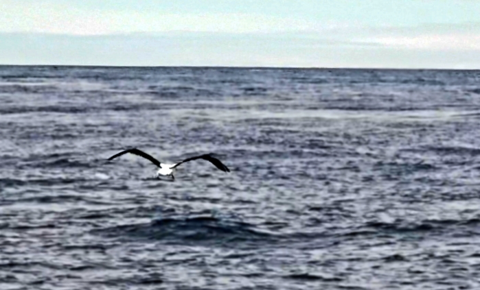
In determining our strategy for crossing the Cook Straight, it was advised to cross with northwest sector winds or minimal winds if possible. It would appear that we have nailed our weather window as well. Our trip across the strait toward Cape Terawhiti was uneventful. Calm seas, light winds with a few penguin sightings and several Albatross. What a wing span they have. The Albatross, not the penguins. LOL
With the Karori Rip between Cape Terawhiti and Sinclair Head ahead of us I charted our course to approximately four miles offshore to avoid any possible rip entanglement. As we passed between the Cape and the Head, we could see some small breaking waves closer toward the shoreline and we were thankful that we weren’t any closer. At one point we had approximately 3.5 knots of tail current pushing us towards Wellington Harbor. This current lasted for almost an hour and a half. Additionally, we did experience several large areas of upwelling currents that pushed us from side to side a bit. The power of the sea is incredible and this was on a calm day. I shudder to think what we would have experienced if the conditions would have been less than favorable.
Wellington Harbor Entrance
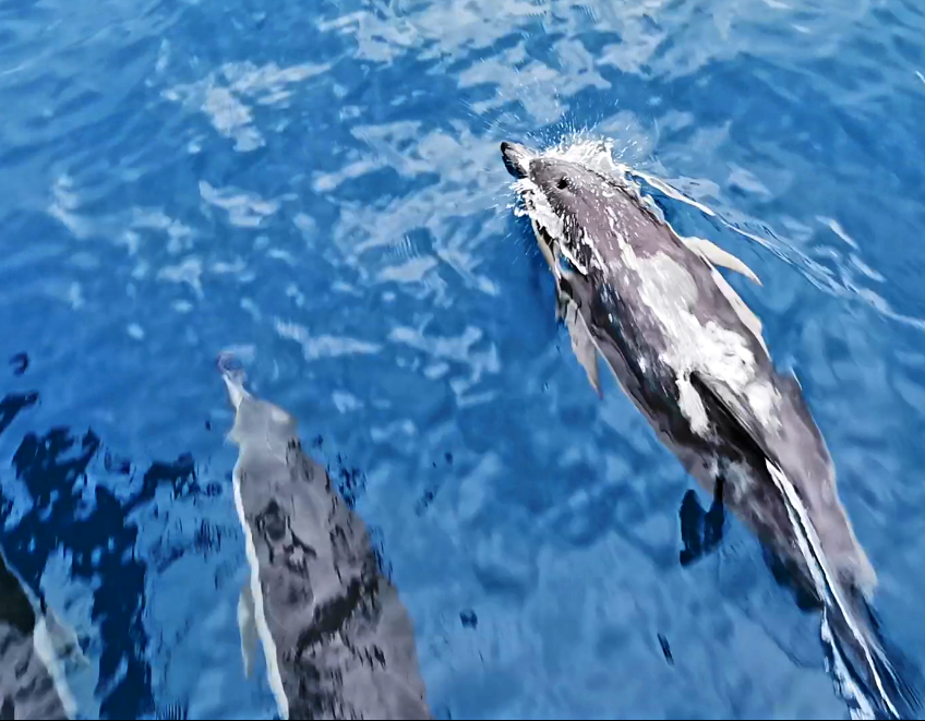
We made it. Yay! As we approached the entrance to Wellington, the winds had done as predicted and clocked around from the south southeast at 8-10 knots. A pod of Bottlenose Dolphin had joined us on our approach and Jilly was on deck with her camera in hand. She could be heard over the sound of the engine whistling, cheering, stomping her feet on deck and telling the dolphins that she loves them. She’s heard they like that kind of interaction. I’m sure the people on the passing ferry heading out into Cook Strait might be thinking there is crazy person kneeling on Dazzler’s bow hurling over the side. Little do they know or can see it’s just our own dolphin whisperer talking to her peeps while parading into the Wellington Harbor entrance. LOL


Before leaving Picton, we had made arrangements to get a slip in Chaffers Marina near downtown Wellington Harbor. We made our way through the navigational aids to Chaffers Marina and safely tied up at our assigned slip. We can now check the Cook Straight box!
It’s now time for our ceremonial anchor down/dock tied celebratory beer. Cheers!
Until our next hair raising adventure. Keep the wet stuff on the outside and you experiences in your heart.
Captain Dan
The following is a list of links to internet sites with information we used in preparation for our crossing.
Met Service Weather For Nelson
Met Service Weather For Wellington
Met Service Weather For Cook Strait
